


|
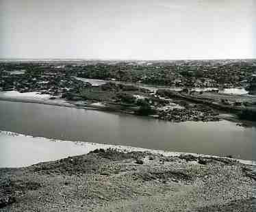
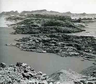
LA SECONDE CATARACTE The Great Cataract was impressive and grandiose. A mineral world in the form of islands, damned up the life giving waters. At Mirgissa, it revealed its full power and splendour. The ochre colour of the sands, the black of the cataract and the blue that unites heaven and earth, each morning reproduce the first day of creation. Multiple channels cut by whirlpools cutting a passage through the granite blocks. From the rock of Abusir and beyond, it confirmed its majesty.
Today, the Great Cataract no longer exists. The same fate has befallen ‘the belly of stone', a mineral prolongation of some 100 km to the south. A lake baptised Nasser has installed itself there. Through respect and duty, we call it, like many, Lake Nubia.
The rocky ensemble has always functioned as a protective bulwark. Nevertheless, the first Egyptian incursion occurs towards the end of the IV Millennium. A king of the first dynasty massacres the populations of the A-Group in the region of Jebel Sheikh Suleiman. A relief commemorates this expedition is engraved on a rock near the Second Cataract.
According to Francis Geus, Egypt, keen to control the southern regions from where it obtained manpower and raw materials, hesitates for a long time to pass beyond this difficult area. But to the north of Buhen, opposite Wadi Halfa, the excavations of Professor Emery unearth a fortified town with a copper foundry dating to the Old Kingdom.
See the slide-show on the Archaeological sites, Unesco Campaign |
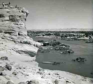      View over the Second cataract of the Nile before its immersion, taken from the Abu-Sir rock (Photo Rex Keating 1960) / Vue sur la Seconde cataracte du Nil avant son immersion, depuis le rocher d'Abou-Sir (Photo Rex Keating 1960)
Granitic rip-rap of the Great cataract (Second cataract or belly stone) blocking the flow of the Nile (Photo R. Keating 1960) / Enrochements de la Grande cataracte (Seconde cataracte ou Ventre de Pierre) barrant le cours du Nil (Photo R. Keating 1960)
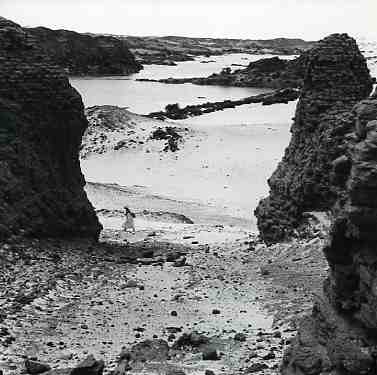
Looking south across the Second cataract through the main fortified gateway of the Shelfak fortress (Photo R. Keating 1960) / Vue de la Seconde cataracte en direction du sud depuis l'entrée principale fortifiée de la forteresse de Shelfak (Photo R. Keating 1960)
Barrier of granitic islands blocking the flow of the Nile between the ruins of the fortresses of Semna East and Semna West (Photo R. Keating 1960) / Barrière d'ilôts granitiques barrant le cours du Nil entre les vestiges des forteresses de Semna Est et de Semna Ouest (Photo R. Keating 1960)
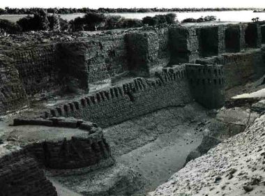
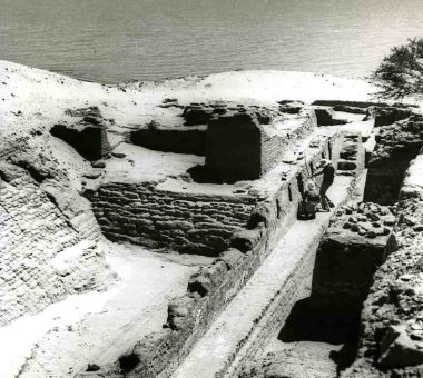
The fortress of Bouhen was situated on the western side of the Second cataract of the Nile (Photo R. Keating 1960) / La forteresse de Bouhen était située sur la rive occidentale du Nil au niveau de la Seconde cataracte (Photo R. Keating 1960)
Defensive system inside the fortress of Bouhen : patrol way and embrasures (Photo R. Keating 1960) / Système défensif aménagé à l'intérieur de la forteresse de Bouhen : chemin de ronde avec meurtrières (Photo R. Keating 1960)
|
|
In the Middle Kingdom Egypt controlled the Second Cataract as far south as Semna. There it built forts. In fact, under Sesostris I (1964-1916 BC), the forts of Buhen and Kor (on the left bank of the Nile downstream from the Second Cataract) are probably economic units. The location of Kor at the end of the rapids of the Great Cataract is of an outpost controlling the sending of goods towards Egypt.
His successor, Amenemhat II (1919-1881 B.C.) constructs, upriver from the cataracts, the fortress of Mirgissa, counterpoint of Kor. It controls the river navigation coming from the south.
During the Second Intermediate Period, it is occupied by a Kerma garrison and during the New Kingdom once more by Egyptians. A children's cemetery of the Napatan period and the remains of a Christian building suggest continuity of occupation. The fort was partially studied by an American team in 1931-1932. Jean Vercoutter took up the excavations when Egypt was authorised by
Sudan to construct the Aswan High Dam. The remains of Pharaonic presence are impressive: - A fortress, a fortified town, an open town, cemeteries, a quay, a small fort and a ramp that allows for the pulling of boats or their cargoes overland from one end to the other of the rapids that block the river in this area. - The location of Mirgissa is mirrored by the presence of a natural harbour bordered by a natural plain. - On an island opposite the fort of Dabenarti dates to the same period. It gives strategic importance to the complex.
According to Francis Geus, who has worked at Mirgissa, this excavation was the most colossal enterprise undertaken by Jean Vercoutter. It runs over more than 2.5 km along the Nile in an essentially rocky environment. To his surprise, the archaeologist discovered in a small sanctuary dedicated to Hathor, ‘mistress of Iu-ka-na', that the famous port of Iken in the Egyptian texts, is no other than the fortress of Mirgissa. The excavations unearthed an impressive number of weapons: lances and javelins with flint heads (some 400) imported from Egypt. The shafts had been devoured by termites but left impressions in the soil. The fort of Semna South is probably built to protect the fort-depot of Mirgissa.
Faced with the growing power of the kingdom of Kerma, Sesostris III (1872-1854 B.C.) erects in the 8th year of his reign a stela at Semna south, at the extremity of the Batn el-Haggar to mark a zone of influence of the Egyptian territory and so as to impede that any Nubian crossing the frontier, be it by land or in a boat, except those that come to trade at Iken (Mirgissa). After 10 years of reign, he installed his camp at Sai. Six years later, he reinforced the Batn el-Haggar and two other stelae are erected at Semna West and at Uronarti. In the texts, he employs threat and disdain to dissuade any Kushite from taking up arms.
The forts of Semna West, Kumna and Uronarti are completed by a line of exceptional defence with Faras, Shelfak and Askut. The fortifications of Buhen and Kor were enlarged. The fortresses of Sesostris III are less important but better adapted to a military strategy. The control of this ‘Maginot line' is undoubtedly carried out from Buhen.
The fortresses stand along the river at strategic locations. They carry aggressive names, for example ‘the one that reduces foreign lands'. They embrace the lie of the land, a half-circle at Askut, a triangle at Uronarti. Their size is impressive. Buhen has been calculated to cover 27 000 sq m., Mirgissa is larger still. It contains official buildings as well as small houses. The excavations have confirmed the presence of granaries, indispensable to an independent life. As for the religious domain, the texts mention the presence of a clergy. Outside the circuit wall, ateliers form industrial areas. A port completed the infrastructure of the fortresses with storehouses, some of which have been identified at Kor, Askut, Uronarti and at Mirgissa.
It is not until the XVIII Dynasty that the fortresses are once more used without defensive purposes, as in the Middle Kingdom. From Buhen to Abu Simbel, the Egyptian settlements bordered the Nile: Argin, Debeira West, Akasha, Serra East and West, Faras East and West. With the creation of the reservoir, most of the constructions in mud brick have been dissolved. Many were almost four thousand years old.
|
|
The Great Cataract was impressive and grandiose. A mineral world in the form of islands, damned up the life giving waters. At Mirgissa, it revealed its full power and splendour. The ochre colour of the sands, the black of the cataract and the blue that unites heaven and earth, each morning reproduce the first day of creation. Multiple channels cut by whirlpools cutting a passage through the granite blocks. From the rock of Abusir and beyond, it confirmed its majesty.
Today, the Great Cataract no longer exists. The same fate has befallen ‘the belly of stone', a mineral prolongation of some 100 km to the south. A lake baptised Nasser has installed itself there. Through respect and duty, we call it, like many, Lake Nubia.
The rocky ensemble has always functioned as a protective bulwark. Nevertheless, the first Egyptian incursion occurs towards the end of the IV Millennium. A king of the first dynasty massacres the populations of the A-Group in the region of Jebel Sheikh Suleiman. A relief commemorates this expedition is engraved on a rock near the Second Cataract.
According to Francis Geus, Egypt, keen to control the southern regions from where it obtained manpower and raw materials, hesitates for a long time to pass beyond this difficult area. But to the north of Buhen, opposite Wadi Halfa, the excavations of Professor Emery unearth a fortified town with a copper foundry dating to the Old Kingdom.